News
ニュース・お知らせ
Creattura Publishes Explainable AI Framework for Monitoring Water Management in Rice Fields from Optical Satellites

TOKYO, June 30, 2026 – Creattura Co.Ltd. today announced the publication of new peer-reviewed research in the IEEE Journal of Selected Topics in Applied Earth Observations and Remote Sensing, one of the most cited journals in satellite-based Earth science, presenting an AI framework that significantly improves the accuracy of surface water detection in paddy rice fields using satellite imagery.
Once rice crops are fully grown, standard satellite tools struggle to tell whether water is actually present — they are essentially guessing. This study shows that combining satellite images with weather and terrain data greatly improves accuracy, detecting many more flooding events that would otherwise go undetected.
“The question was never which sensor is best in isolation. It was always which combination of factors best explains what is happening in the field. We hope this study helps shift the assumption that SAR1 is the only viable path for monitoring water management in rice paddies — when properly contextualized, optical data can do more than the industry has given it credit for.”
— Alexis Declaro, Head of Data Science &GIS, Creattura Co. Ltd.
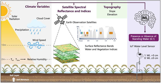
What distinguishes this framework is not simply the integration of more data,but a clear understanding of what each input represents. Each factor reflects observable field conditions — how crop canopies interact with water, the moisture levels in air and soil, and how terrain naturally directs water flow. Because the framework produces transparent, explainable predictions, it can be reliably applied in real-world farming environments. This research forms the scientific foundation of Creattura’s SWAP2model, the company’s operational system for near-daily field-level water monitoring in paddy landscapes using multi-source satellite data. Through this system, Creattura aims to enable large-scale monitoring of water-saving practices such as Alternate Wetting and Drying3,eliminating the need for manual measurements in individual paddies.
PUBLICATION DETAILS
Title: Data-Driven Assessment of Climate and Topographic Integration With Satellite Imagery for Improved Surface Water Detection Under Agricultural Vegetation
Authors: Alexis Declaro, Jin Xiao, Robert Galla, Prof. Shinjiro Kanae (Institute of Science Tokyo / University of Yamanashi)
Journal:IEEE Journal of Selected Topics in Applied Earth Observations and Remote Sensing (JSTARS)
DOI: 10.1109/JSTARS.2026.3699594
1 Synthetic Aperture Radar (SAR) is atype of radar satellite that uses radio waves rather than light, allowing it to see-through clouds and dense vegetation.
2 Surface Water Absence and Presence (SWAP) is Creattura's operational platform for monitoring surface water in paddy rice fields from space, combining multiple satellite sources to deliver near-daily observations at the individual field level.
3 Alternate Wetting and Drying (AWD) is a rice irrigation practice that alternates flooding and drying cycles, reducing water use by up to 38% and methane emissions by approximately 48% without reducing yield.
Related
Creattura Publishes Explainable AI Framework for Monitoring Water Management in Rice Fields from Optical Satellites
For service inquiries and consultations, click here.